Presque Isle Bay No Wake Zone
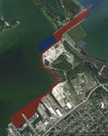
As you get to the channel heading to the lake in Presque Isle Bay you can see the no wake sign on the northwest pierhead. For years I have wondered if the area directly to the west of that was intended to be no wake as well. This is the area where the sand and gravel ships dock. After reading the PA Code on it I am not sure because I don't know what all of the reference points they use are. I especially don't know what the Inter Range Tower, Continental Grain Company pier, and the Harbor Line are. I have included a picture. In red is what I know to be no wake and in blue is the area in question and what I "think" the code says is no wake. Also not sure why they didn't give "the area adjacent to the Erie Public Dock" its own bullet point unless they are trying to say the whole southeast corner of the bay is no wake. Anyone familiar with these reference points enough to point out where the no wake zone actually is?
Here is the code pasted from pacode.com(only the part I am referenceing):
[style="font-family: 'helvetica neue', arial, helvetica, sans-serif;"]
§ 111.25. Erie County.
(a)
Lake Erie and Presque Isle Bay. (1) Boats are limited to slow, no wake speed in the following areas:
(i) Through the Erie Harbor Entrance between the North Pierhead Light (fog horn) and Inter Range Tower.
(ii) In the area adjacent to the Erie Public Dock, extending from the Erie Sand and Gravel Company on the west to the Continental Grain Company piers on the east. The restricted area will include the Canal Basin and extend northward to the harbor line.
Attached Image(s)