chance33
New Angler

- Total Posts : 21
- Reward points: 0
- Status: offline
Lake Erie Map
My central basin map shows a "dumping ground" a mile or so north of the PI point. Is this a must avoid area??
|
Erie Mako
Expert Angler

- Total Posts : 452
- Reward points: 0
- Joined: 2010/06/25 14:32:48
- Location: Indiana County, PA
- Status: online

RE: Lake Erie Map
2011/09/19 19:08:20
(permalink)
No.
There are lots of dumping grounds that aren't even marked.
On the internet, EVERYONE is entitled to their opinion!
|
genieman77
Pro Angler

- Total Posts : 2780
- Reward points: 0
- Status: offline

RE: Lake Erie Map
2011/09/19 22:49:46
(permalink)
what are they 'dumping"??
.L.T.A.
|
SteelSlayer77
Expert Angler

- Total Posts : 489
- Reward points: 0
- Joined: 2010/08/31 21:00:00
- Status: offline

RE: Lake Erie Map
2011/09/19 23:07:13
(permalink)
|
heyiknowyou
Pro Angler

- Total Posts : 1279
- Reward points: 0
- Joined: 2009/09/17 12:41:25
- Location: erie
- Status: offline

RE: Lake Erie Map
2011/09/19 23:23:55
(permalink)
ORIGINAL: genieman77
what are they 'dumping"??
.L.T.A.
frack water from the marcellus wells
go back to spain 11-12-11: the last time i got punched in the face
|
RELAYER
Expert Angler

- Total Posts : 465
- Reward points: 0
- Joined: 2000/07/24 11:13:48
- Status: offline

RE: Lake Erie Map
2011/09/20 07:02:14
(permalink)
I think it's the runoff water from the streets in the city,I may be wrong but that's my guess.
|
CKM
New Angler

- Total Posts : 25
- Reward points: 0
- Joined: 2000/06/23 14:43:13
- Status: offline

RE: Lake Erie Map
2011/09/20 12:11:34
(permalink)
I believe it is dredging spoils (i.e from the channel and turning basin in the bay), when they (ACOE/EPA?) allowed open lake disposal of these materials. I'm not sure it's used anymore. There are no navigational hazards in this area, if that's your concern. oops.....sorry I missed the link that SteelSlayer77 posted that provided an answer.
post edited by CKM - 2011/09/20 12:15:05
|
ShutUpNFish 
Pro Angler

- Total Posts : 3834
- Reward points: 0
- Joined: 2007/03/16 10:31:34
- Status: offline

RE: Lake Erie Map
2011/09/20 13:00:10
(permalink)
Typically sediment that they dredge from the harbors.....oh wait, there arent any harbors in PA....thats right, my bad 
|
Ironhed
Pro Angler

- Total Posts : 1892
- Reward points: 0
- Joined: 2001/11/07 19:10:08
- Status: offline

RE: Lake Erie Map
2011/09/20 13:13:24
(permalink)
And you think, Conneaut, the "Crystal Meth Capital of the World" is a harbor? LMAO For most of this summer, the channels in and outside of Presque Isle Bay were dredged, as they are every few years, and the spoils were taken to the area off the point that the OP mentioned and discarded. Many a bass tourney has been won off of that area. Walleye like it too.  Ironhed
|
Trout About
Pro Angler

- Total Posts : 1048
- Reward points: 0
- Joined: 2001/11/24 21:32:27
- Location: West Newton, PA
- Status: offline

RE: Lake Erie Map
2011/09/20 22:49:21
(permalink)
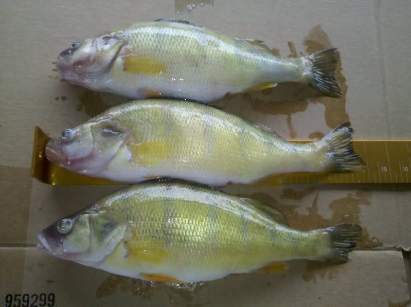
You better avoid areas like that, unless you want to catch something like this. We were bass fisnin' out there a few weeks ago and kept throwing 10" perch back. When we hooked up with these, I said "you have to die, you look too tasty". at the end of the day, I was wishing we had kept those 10" ones too! 
|
heyiknowyou
Pro Angler

- Total Posts : 1279
- Reward points: 0
- Joined: 2009/09/17 12:41:25
- Location: erie
- Status: offline

RE: Lake Erie Map
2011/09/20 23:24:25
(permalink)
lies, thats a metric ruler
go back to spain 11-12-11: the last time i got punched in the face
|